Pelican and Blacksmiths: Planning for Future Flood and Coastal Risks
Council adopted the Local Adaptation Plan for Pelican, Blacksmiths, Swansea, Swansea Heads and Caves Beach on 25 October 2021. You can view the Council report here.
You can view the Local Adaptation Plan webpage for more information.
Local adaptation planning assists coastal communities that may be vulnerable to flooding and tidal inundation impacts as sea and lake levels rise. Pelican and Blacksmiths each have future flood and coastal risks unique to these areas.
Planning to adapt communities over time to mitigate future flood risks allows local residents and businesses to assess the risks early, tailor adaptation options to meet local needs and act when and where necessary. We are working together to keep our community safe now and in the future. Decisions we make can have lasting impacts. Many of the new roads, drains and homes built today will likely still be around in 50 to 100 years, so we need to plan for the future now.
This page has online resources that will keep you up to date with the development of this local adaption plan and we encourage you to provide your feedback or ask a question.
-
Phase B Community Workshop No. 1 - Thursday 11 August - What are the options?
Share Phase B Community Workshop No. 1 - Thursday 11 August - What are the options? on Facebook Share Phase B Community Workshop No. 1 - Thursday 11 August - What are the options? on Twitter Share Phase B Community Workshop No. 1 - Thursday 11 August - What are the options? on Linkedin Email Phase B Community Workshop No. 1 - Thursday 11 August - What are the options? link
We’ve heard your ideas for how to respond to ongoing sea level rise, higher future flood levels and beach erosion in Pelican and Blacksmiths.
At this event, we’ll take a more detailed look at these ideas, consider where and how they could be implemented and check if there are other options that have not been suggested to date.
Date: Thursday 11 August
Time: 6 - 8:30pm
Where: Swansea Belmont Surf Club
-
Thank you for getting involved!
Share Thank you for getting involved! on Facebook Share Thank you for getting involved! on Twitter Share Thank you for getting involved! on Linkedin Email Thank you for getting involved! link
Thanks to everyone who braved the wet weather and joined us over the weekend at Blacksmiths Surf Club.
The event helped local residents and visitors to the area to better understand how sea level rise may affect them by using virtual reality technology, such as Oculus Rift and Google Cardboard headsets!
The project team reported back on the type of community feedback that has been received to date, and asked attendees to identify additional issues/suggestions, or try their hand at dot democracy so we could learn what potential risk management strategies they like or dislike.
-
Raincheck for free sausage sizzle at Pelican foreshore
Share Raincheck for free sausage sizzle at Pelican foreshore on Facebook Share Raincheck for free sausage sizzle at Pelican foreshore on Twitter Share Raincheck for free sausage sizzle at Pelican foreshore on Linkedin Email Raincheck for free sausage sizzle at Pelican foreshore link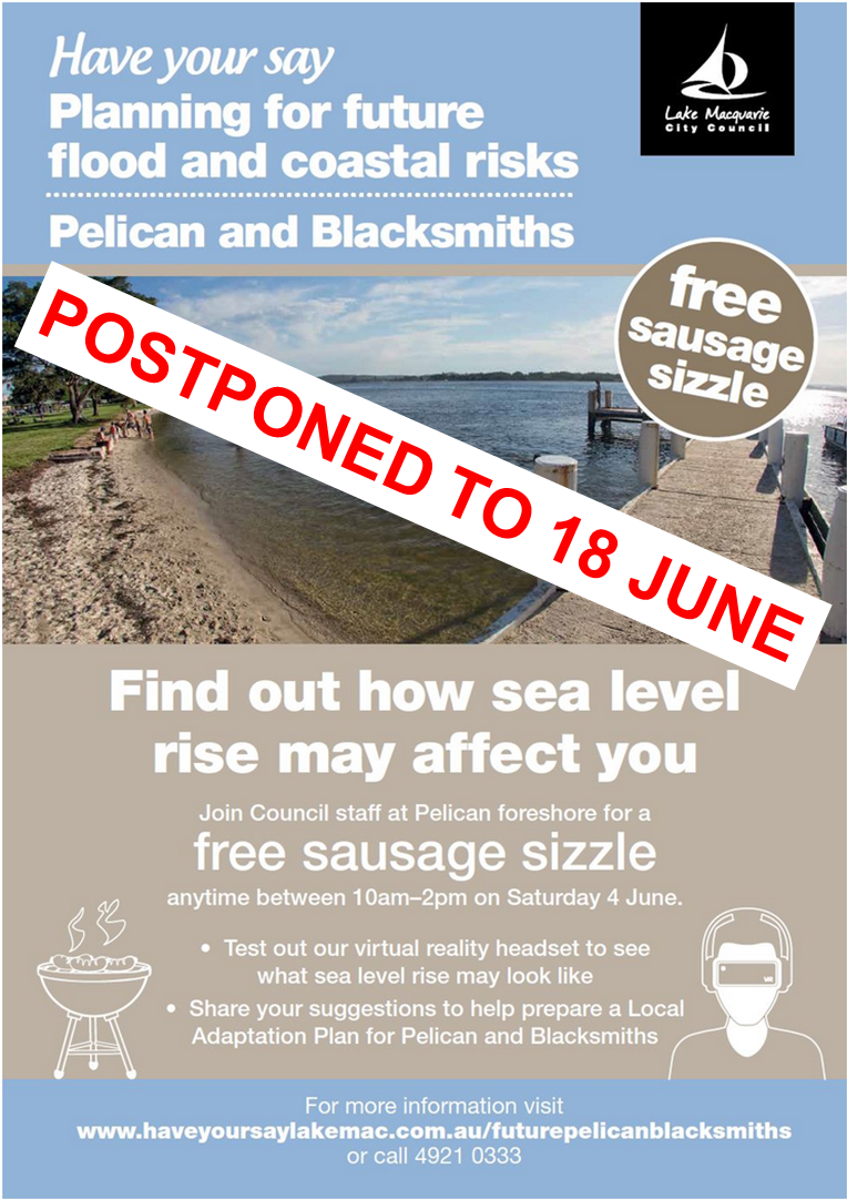
Due to forecast inclement weather, Lake Macquarie City Council has postponed Saturday’s free sausage sizzle at Pelican foreshore.The event, which will help local residents and visitors to Pelican and Blacksmiths better understand how sea level rise may affect them, has been rescheduled for Saturday 18 June, at Pelican foreshore.
Council will make virtual reality technology, such as Oculus Rift and Google Cardboard headsets available to those who attend the sausage sizzle, to demonstrate how sea level rise may affect the Pelican foreshore in the future.
Free sausage sizzle
When: anytime between 10am-2pm on Saturday 18 June
Where: Pelican foreshore (Swansea Belmont Surf Club in the case of inclement weather)
For more information visit www.haveyoursaylakemac.com.au/futurepelicanblacksmiths or call 4921 0333.
-
Upcoming event - Find out how sea level rise may affect you
Share Upcoming event - Find out how sea level rise may affect you on Facebook Share Upcoming event - Find out how sea level rise may affect you on Twitter Share Upcoming event - Find out how sea level rise may affect you on Linkedin Email Upcoming event - Find out how sea level rise may affect you linkJoin Council staff at Pelican foreshore for a free sausage sizzle any time between 10am - 2pm on Saturday 18 June.
- Test out our virtual reality headset to see what sea level rise may look like
- View maps showing the extent of projected future flooding and sea level rise
- Share your suggestions to help prepare a Local Adaptation Plan for Pelican and Blacksmiths

-
Insights from 17 March Q&A event - your questions
Share Insights from 17 March Q&A event - your questions on Facebook Share Insights from 17 March Q&A event - your questions on Twitter Share Insights from 17 March Q&A event - your questions on Linkedin Email Insights from 17 March Q&A event - your questions linkOn Thursday 17 March, residents were given the opportunity to engage with Council staff and independent specialists in coastal, channel and flooding hazards, and to explore ways we can plan for future uncertainty.
The following questions offer some insight into the discussions during the event. We will explore these questions further in upcoming community workshops. As we move forward, we will start to provide answers to your questions from this event and other events on the project website. You can ask us a question at any time.
How do we develop a Local Adaptation Plan for Pelican and Blacksmiths? Can we learn from the Marks Point and Belmont South experience?
How does this adaptation plan address planning for resilience against flooding, and incorporating land use planning under the coastal zone management plan?Are there any management models from other coastal communities we can adopt?
What opportunities for dune nourishment work to protect the beach?Low-lying suburban roads and drainage systems – to what extent do blockages contribute to issues? How often does Council respond to drainage service requests?
Roads need to be raised for evacuation, if necessary. Is the Roads and Maritime Service (RMS) on board with resolutions from the Marks Point and Belmont South Local Adaptation Plan?
Can we incorporate other climate change issues in adaptation planning? For example, increased temperature, warming of lake and ocean; shade, raised building and infrastructure solutions…
Is the collapse of Milanos a consequence of dredging, sand islands, or channel scour from the entrance training walls?
Manly Hydraulics monitors three tidal gauges in Lake Macquarie at Belmont, Marmong Point and Swansea. Do flood waters from Dora Creek, Eraring and the Hunter Valley influence lake levels? How?
Could the water table be lowered by planting paperbark and tea trees? Would this help manage storm water flooding?
If moving Pelican boat ramp has to happen, are there plans to address erosion issues at the airport?
-
A day out to talk tides, rains and drains
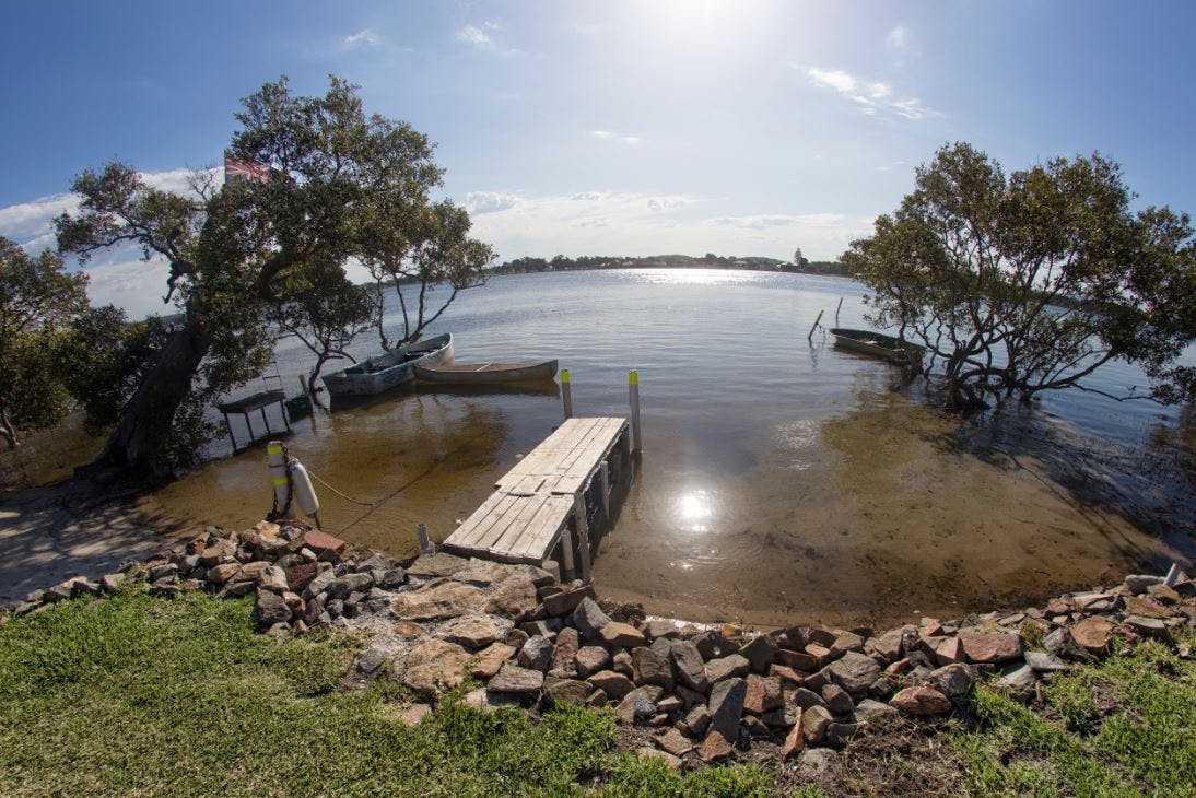
Share A day out to talk tides, rains and drains on Facebook Share A day out to talk tides, rains and drains on Twitter Share A day out to talk tides, rains and drains on Linkedin Email A day out to talk tides, rains and drains linkIt was a warm day, the sun was shining and the tide was high. Nineteen residents from the local area and some as far as Wallsend joined Council staff on a tour to learn about the effects of the King Tide on drainage and to see what projected sea level rise could look like in the future.
The King Tide reached about 1.97 metres, equivalent to just below 1 metre AHD (1m AHD is approximately the same as 1m above average sea level).
This King Tide was slightly lower than previous years. The 2014 King Tide, for example, reached 2.04 metres. Many factors, such as whether there is a low-pressure system, influence how high a King Tide will be on the day.
The tidal range varies around the Australian coast. Here in Lake Macquarie, we experience a tidal range of around ±0.5 however, in other parts it can be ±3-9m, and the largest, in Geraldton in WA is 11m. The tidal range within the lake is much lower, around ±0.05 as the channel restricts the flow in and out of the lake.
Tour sites and discussion included:
Swansea Channel Tidal Gauge
This gauge is monitored by Manly Hydraulics Laboratory and generates tidal record data. There are three water level gauges in Lake Macquarie operated by the NSW Government, at Swansea, Belmont and Marmong Point. These gauges measure water levels relative to a fixed point on the land. The nearest fully calibrated gauge, is at Port Kembla and is operated by the Australian Bureau of Meteorology, shows a rise of 2.6mm a year since it began measurements in 1991.
Based on historical records and complex computer modelling, sea levels on the NSW coast are projected to rise 0.9 metres by 2100. This projection accounts for some uncertainty around melting of land ice and also allows for an acceleration in the East Australian Current.
Effect on stormwater drainage
The tour group witnessed lake water rising up into stormwater drains and were asked to think about what this means in the future if a King Tide was to occur on top of 0.9 metre sea level rise by the end of the century. Drains currently at the same elevation of the lake, or below, will need to be re-designed, along with other infrastructure to enable effective functioning.
Blacksmiths Breakwall and evolution of the Channel
The Channel has been responding to engineered modifications of the entrance that started over 150 years ago. The State Government is currently investigating the recent collapse of Milanos to try to understand the contribution that channel evolution may have had to the erosion of the Pelican foreshore and the incident.
Blacksmiths beach dunes
The dunes protect the Blacksmiths and Pelican communities. Local groups have put in many volunteer hours into rehabilitating the dunes after years of sand mining. Council monitors changes to the beach profile on an ongoing basis. Around 30 years of data is needed to detect any significant trends in beach recession and erosion.


-
Residents of Pelican and Blacksmiths contribute ideas for the future
Share Residents of Pelican and Blacksmiths contribute ideas for the future on Facebook Share Residents of Pelican and Blacksmiths contribute ideas for the future on Twitter Share Residents of Pelican and Blacksmiths contribute ideas for the future on Linkedin Email Residents of Pelican and Blacksmiths contribute ideas for the future linkCouncil met with some residents of Pelican and Blacksmiths in late 2015 to listen and talk about opportunities for the community to help plan for the future of the area and prepare a Local Adaptation Plan.
The primary objective of these sessions was to listen and build relationships, in order to help scope and design the project.
A secondary objective was to gauge people’s interest in participating in the planning process scheduled for 2016.
We asked participants:
- What can you tell us about the area? Are there any issues you would like to raise?
- Are there any flooding or foreshore (coastal or lake) management issues you would like to raise for Council to consider?
- What do you value about the area?
- How would you like to be involved?
Council staff were also on hand to talk about the draft Marks Point and Belmont South Local Adaptation Plan.
 Participants contributed more than 40 ideas about ideas for the future and current issues or observations. Council and the community will draw on this information again in community workshops scheduled for later this year. These comments have been uploaded to an interactive map.We are now giving everyone the opportunity to have their say, whether you live in Pelican and Blacksmiths or elsewhere.
Add your ideas to our interactive map!

Read the latest engagement summary

Document Library
-
 Feasibility Assessment FAQs (172 KB) (pdf)
-
Options guide for the cost benefit analysis (2.72 MB) (pdf)
-
Feasibility Assessment Report - Pelican and Blacksmiths/Swansea and Surrounds (9.86 MB) (pdf)
-
Let's Talk - Cost Benefit Analysis CIE Presentation 30 Nov 2020.pdf (290 KB) (pdf)
-
CBA Report Executive Summary.pdf (188 KB) (pdf)
-
Probabilistic Hazard Assessment.pdf (14.5 MB) (pdf)
-
 Records of wider community engagement
-
Newsletters
Who's listening
-
Lake Macquarie City Council
Phone 02 4921 0333 Email [email protected] -
Senior Sustainability Officer – Climate Change Adaptation