
Coastal Zone Management Plan
Consultation has concluded
Many residents who live, work or play on the coast have had their say on the draft Coastal Zone Management Plan. Thank you to everyone who took part in the consultation which closed on 31 January 2015.
A consultation report that summarises feedback received online, in workshops and in formal submissions is now available. The revised Plan and Four Year Action Plan are also avaialbe in the document library. You can also still Ask us a Question in the tab below.
The coastal zone covers the coastline (beaches), estuary (lake and catchment) and Swansea channel. Management plans and hazard assessments have been prepared for all three parts of the coastal zone.
The Four Year Action Plan identifies a number of management issues and recommends actions that promote a healthy lifestyle and consider current climate change predictions; coastal assets; public access and increased recreational pressure in this coastal city.
-
Share General comment: it would be good to include the location and date of the photographs used in the documents so the public can familiarize with these locations and make observations of the environment and the impacts of the coastal hazards. Most of the proposed actions heavily focus on assessing the condition and management of the ecological environment and not the physical condition of the coastal environment including the channel, lake and estuaries and the physical hazards resulting from sea level rise and tidal inundation. Assessing the condition and management of the ecological environment is already part of the Council core responsibility to report on the Lake Macquarie Catchment state of the environment. It should complement the actions for the coastal zone management plan. The management of the coast cannot rely on nature to do the work when nature is working on the opposite direction where sea level rise eventually will result in reclaiming dry land. A successful coastal management plan would require building physical foreshore protection structures and monitoring programs to save important land that is economically viable for continuous restoration. This submission is a review of the draft Coastal Zone Management Plan Framework. The mayor's foreword stated "other land managers and public authorities, including NSW Trade and Investment (Crown Lands Division), Department of Primary Industries (Fisheries Division), Office of Environment and Heritage, Hunter Water Corporation, Roads and Maritime Services, Local Land Services, and other coastal land managers such as Belmont Wetlands State Park Trust and Belmont Golf Club have an important role to play in delivering the actions outlined in the plan." Are these agencies contacted and invited to comment, specially Roads & Maritime, LLS local business organisations and other community organisations such as the progress groups. Are submissions going to be reported back to the community. Under 'Key Responsibilities' the actions of Wyong Shire was identified as a major contributor to maintaining the health of the lake. However Newcastle City Council was not mentioned as contributor to the actions that aim to deliver consistent outcomes in managing the impacts of sea level rise. Table 1 – Objects of the Coastal Protection Act Under 'Appropriate land tenure' which state 'to provide for the acquisition of land in the coastal region, to promote the protection, enhancement, maintenance and restoration of the environment of the coastal region. If the environment is permanently affected by rising sea level what is to be achieved by restoring and maintaining land that will be repeatedly subject to erosion or flooding and how is it going to be viable. This section should include a statement to declare land that is untenable for the safety of the community and rezoning the land to a more appropriate landuse. What about protecting and maintaining property rights? Does acquisition involve fair compensation of landholders affected by coastal erosion, consistent lake flooding and permanent inundation? Under 'Çommunity and stakeholder attitudes to change along the Lake Macquarie coastline' it states that 'The coastline of Lake Macquarie has: • to manage community resistance to urbanisation of the coastline' Is this community the majority or minority? Could this be a perception from a few members of the community close to Council staff. Majority of the lake is currently urbanised, probably not as big compared to other major cities but the population growth in NSW will result in the lake having a fair share of the population growth. It is only realistic to presume that Lake Macquarie including the coastline will continue to develop as an urban area. I think the community is not completely resistant to urbanisation but is opposing only certain developments that are not socially compatible and do not fit the community needs. About Lake Macquarie estuary land uses and recreational values The Lake Macquarie estuary has: ?extensive urban and industrial development, and particularly low-lying development. Lake Macquarie has approximately 70 km of absolute waterfront residential development, much of it less than 2 metres above mean sea level, and has been identified as one of the highest risk areas in Australia for inundation of property and infrastructure assets as sea level rises. The predicted maximum sea level rise in 100 years is 0.9 m and the mean elevation of waterfront properties is 0.5 AHD. If this is the case why are land <2 metres AHD at high risk when land at 2 metres AHD will still be above water after sea level rise. Actual risk and predicted risk are not the same in the context of time. Why are land <2 m being classified as high risk now when the hazard has not occurred yet. Should the term 'potential high risk areas' more appropriate. ?continuing population growth in the local area and the region, increasing pressure for residential redevelopment of foreshores, and for structures and facilities to protect private property The last phrase needs to be separated as this has to do with foreshore protection to protect private as well as public land. This would emphasize the need to allow and plan for building of major structures and facilities for foreshore protection on Crown land. This section needs to include: - the demand for liveable and accessible area for the elderly and retirees who require level (flat) land with facilities close by or easily accessible. - it is also the site of the upmarket waterfront marina village (Trinity Pt) offering holiday units that will draw more tourists and residential units resulting in increase in people moving in to the lake and development of associated facilities.) A-A-A - Avoiding, Accommodating, Accepting Adapting is probably more appropriate than accommodating the CZMP and its priority actions Community and agency consultation to develop this CZMP commenced in March 2012 I have been a member of the Belmont St and Marks Pt community subcommittee and I am not aware of any consultation prior to the draft plan submission for comments ?other land and asset managers including the Crown Lands Department within NSW Trade and Investment, Belmont Wetlands State Park Trust, Belmont Golf Club, Origin Energy, marina owners; Is the Local Land Services, the responsible agency under CMA and identified as one of the stakeholders, consulted. Council should investigate what LLS can contribute in terms of funding studies and on ground works? Table 2 - Ownership of Priority Assets This table needs to include monitoring sites both state and council owned. These would need an assessment whether monitoring can continue, which ones need replacement, relocating and maintenance when sites are affected by the coastal hazards. Theme 1: Options to Manage Coastal Process Hazards and Risk Risk Coastline – Conduct an audit of the foundations of all surf clubs, as well as the Redhead SLSC seawall when conditions allow The hazards and risk of rising sea level includes salinity problems. As the sea level rise, the groundwater table (which is most of the time brackish) also rise. This leads to capillary action and deposition of salts in concrete and brick foundations. LLS is the lead agency responsible for salinity management including urban salinity. The agency with the help of the building industry association developed a building guideline in saline environment. Council should ask assistance and guidance with LLS to tackle urban salinity problem in coastal areas. Has Council considered: - building seawall at Belmont WWTP including part of Belmont St to protect the sand dune. -building protection works at Belmont Bay foreshore. Is this not going to be required in the event of of 0.9 metre sea level rise? - Belmont Lagoon. If the lagoon is breached by tidal inundation specially during storms, measures should be put in place to prevent tidal water from flooding Belmont South Theme 1: Options to Manage Coastal Process Hazards and Risk Use clauses in the DCP to require new development in relevant coastal risk planning areas to incorporate design features to accommodate coastal risks. These include peered (replace with pier) foundations (to a stable foundation depth), floor levels to prevent marine inundation, and light weight or modular structures for relocation What about raised slab, slab on bearers and joist or slab on fill? Theme 2 Actions for a healthy coastal zone - protecting biodiversity and ecological resilience Add in Objectives for Theme 2 - encourage groundwater use in low lying areas to reduce the water table - encourage water recycling and rain water harvesting through use of rainwater tank - promote water sensitive urban design, e.g. vegetated swales to control local runoff, vegetated drainage lines to enhance infiltration and reduce runoff On-ground Coastline – Focus on control of Bitou bush by eliminating new colonisation on dunes, headlands and around wetlands, as a priority. This may require revisiting ‘cleaned up’ sites to remove new seedlings Any vegetation helps in controlling erosion. I suggest control of Bitou Bush only in areas used for recreation and if it needs removal that it is replaced by native species. Lifeguard team or equivalent committed to follow up bitou bush eradication Is this a job for the lifeguards or should it be the Landcare groups and Progress associations? $85,000 per annum Lake Health Annual Report I recommend the report to include assessment of beach health. Establish a mooring working group, to make recommendations on reducing mooring impacts on sensitive seagrass beds I think before this action we really need to determine if mooring impacts important seagrass colonies. Seagrass may be growing in established mooring areas but the impact of mooring on this vegetation would be minor in terms of the hazards of rising sea levels. Important sea grass colonies outside of mooring areas need to be identified and warrants monitoring to determine how they are coping with the change in their environment brought by sea level rise. Review DCP guidelines on best practice jetty designs suitable for installation in Lake Macquarie. more important is that these structures are located and designed to withstand or adapt to the coastal hazard so that public money invested on their construction is not wasted. Theme 3 Actions for sustainable community access, use and value Objectives for Theme 3: Need to include in the objectives - to maintain a retiree-friendly city. The 2011 census indicates that 18.4% of the population in Lake Macquarie is 65 yrs and over. The coastal areas are particularly sought after by retirees due to the level access and proximity of important facilities such as hospital, clinics, transport and shopping centres on Facebook Share General comment: it would be good to include the location and date of the photographs used in the documents so the public can familiarize with these locations and make observations of the environment and the impacts of the coastal hazards. Most of the proposed actions heavily focus on assessing the condition and management of the ecological environment and not the physical condition of the coastal environment including the channel, lake and estuaries and the physical hazards resulting from sea level rise and tidal inundation. Assessing the condition and management of the ecological environment is already part of the Council core responsibility to report on the Lake Macquarie Catchment state of the environment. It should complement the actions for the coastal zone management plan. The management of the coast cannot rely on nature to do the work when nature is working on the opposite direction where sea level rise eventually will result in reclaiming dry land. A successful coastal management plan would require building physical foreshore protection structures and monitoring programs to save important land that is economically viable for continuous restoration. This submission is a review of the draft Coastal Zone Management Plan Framework. The mayor's foreword stated "other land managers and public authorities, including NSW Trade and Investment (Crown Lands Division), Department of Primary Industries (Fisheries Division), Office of Environment and Heritage, Hunter Water Corporation, Roads and Maritime Services, Local Land Services, and other coastal land managers such as Belmont Wetlands State Park Trust and Belmont Golf Club have an important role to play in delivering the actions outlined in the plan." Are these agencies contacted and invited to comment, specially Roads & Maritime, LLS local business organisations and other community organisations such as the progress groups. Are submissions going to be reported back to the community. Under 'Key Responsibilities' the actions of Wyong Shire was identified as a major contributor to maintaining the health of the lake. However Newcastle City Council was not mentioned as contributor to the actions that aim to deliver consistent outcomes in managing the impacts of sea level rise. Table 1 – Objects of the Coastal Protection Act Under 'Appropriate land tenure' which state 'to provide for the acquisition of land in the coastal region, to promote the protection, enhancement, maintenance and restoration of the environment of the coastal region. If the environment is permanently affected by rising sea level what is to be achieved by restoring and maintaining land that will be repeatedly subject to erosion or flooding and how is it going to be viable. This section should include a statement to declare land that is untenable for the safety of the community and rezoning the land to a more appropriate landuse. What about protecting and maintaining property rights? Does acquisition involve fair compensation of landholders affected by coastal erosion, consistent lake flooding and permanent inundation? Under 'Çommunity and stakeholder attitudes to change along the Lake Macquarie coastline' it states that 'The coastline of Lake Macquarie has: • to manage community resistance to urbanisation of the coastline' Is this community the majority or minority? Could this be a perception from a few members of the community close to Council staff. Majority of the lake is currently urbanised, probably not as big compared to other major cities but the population growth in NSW will result in the lake having a fair share of the population growth. It is only realistic to presume that Lake Macquarie including the coastline will continue to develop as an urban area. I think the community is not completely resistant to urbanisation but is opposing only certain developments that are not socially compatible and do not fit the community needs. About Lake Macquarie estuary land uses and recreational values The Lake Macquarie estuary has: ?extensive urban and industrial development, and particularly low-lying development. Lake Macquarie has approximately 70 km of absolute waterfront residential development, much of it less than 2 metres above mean sea level, and has been identified as one of the highest risk areas in Australia for inundation of property and infrastructure assets as sea level rises. The predicted maximum sea level rise in 100 years is 0.9 m and the mean elevation of waterfront properties is 0.5 AHD. If this is the case why are land <2 metres AHD at high risk when land at 2 metres AHD will still be above water after sea level rise. Actual risk and predicted risk are not the same in the context of time. Why are land <2 m being classified as high risk now when the hazard has not occurred yet. Should the term 'potential high risk areas' more appropriate. ?continuing population growth in the local area and the region, increasing pressure for residential redevelopment of foreshores, and for structures and facilities to protect private property The last phrase needs to be separated as this has to do with foreshore protection to protect private as well as public land. This would emphasize the need to allow and plan for building of major structures and facilities for foreshore protection on Crown land. This section needs to include: - the demand for liveable and accessible area for the elderly and retirees who require level (flat) land with facilities close by or easily accessible. - it is also the site of the upmarket waterfront marina village (Trinity Pt) offering holiday units that will draw more tourists and residential units resulting in increase in people moving in to the lake and development of associated facilities.) A-A-A - Avoiding, Accommodating, Accepting Adapting is probably more appropriate than accommodating the CZMP and its priority actions Community and agency consultation to develop this CZMP commenced in March 2012 I have been a member of the Belmont St and Marks Pt community subcommittee and I am not aware of any consultation prior to the draft plan submission for comments ?other land and asset managers including the Crown Lands Department within NSW Trade and Investment, Belmont Wetlands State Park Trust, Belmont Golf Club, Origin Energy, marina owners; Is the Local Land Services, the responsible agency under CMA and identified as one of the stakeholders, consulted. Council should investigate what LLS can contribute in terms of funding studies and on ground works? Table 2 - Ownership of Priority Assets This table needs to include monitoring sites both state and council owned. These would need an assessment whether monitoring can continue, which ones need replacement, relocating and maintenance when sites are affected by the coastal hazards. Theme 1: Options to Manage Coastal Process Hazards and Risk Risk Coastline – Conduct an audit of the foundations of all surf clubs, as well as the Redhead SLSC seawall when conditions allow The hazards and risk of rising sea level includes salinity problems. As the sea level rise, the groundwater table (which is most of the time brackish) also rise. This leads to capillary action and deposition of salts in concrete and brick foundations. LLS is the lead agency responsible for salinity management including urban salinity. The agency with the help of the building industry association developed a building guideline in saline environment. Council should ask assistance and guidance with LLS to tackle urban salinity problem in coastal areas. Has Council considered: - building seawall at Belmont WWTP including part of Belmont St to protect the sand dune. -building protection works at Belmont Bay foreshore. Is this not going to be required in the event of of 0.9 metre sea level rise? - Belmont Lagoon. If the lagoon is breached by tidal inundation specially during storms, measures should be put in place to prevent tidal water from flooding Belmont South Theme 1: Options to Manage Coastal Process Hazards and Risk Use clauses in the DCP to require new development in relevant coastal risk planning areas to incorporate design features to accommodate coastal risks. These include peered (replace with pier) foundations (to a stable foundation depth), floor levels to prevent marine inundation, and light weight or modular structures for relocation What about raised slab, slab on bearers and joist or slab on fill? Theme 2 Actions for a healthy coastal zone - protecting biodiversity and ecological resilience Add in Objectives for Theme 2 - encourage groundwater use in low lying areas to reduce the water table - encourage water recycling and rain water harvesting through use of rainwater tank - promote water sensitive urban design, e.g. vegetated swales to control local runoff, vegetated drainage lines to enhance infiltration and reduce runoff On-ground Coastline – Focus on control of Bitou bush by eliminating new colonisation on dunes, headlands and around wetlands, as a priority. This may require revisiting ‘cleaned up’ sites to remove new seedlings Any vegetation helps in controlling erosion. I suggest control of Bitou Bush only in areas used for recreation and if it needs removal that it is replaced by native species. Lifeguard team or equivalent committed to follow up bitou bush eradication Is this a job for the lifeguards or should it be the Landcare groups and Progress associations? $85,000 per annum Lake Health Annual Report I recommend the report to include assessment of beach health. Establish a mooring working group, to make recommendations on reducing mooring impacts on sensitive seagrass beds I think before this action we really need to determine if mooring impacts important seagrass colonies. Seagrass may be growing in established mooring areas but the impact of mooring on this vegetation would be minor in terms of the hazards of rising sea levels. Important sea grass colonies outside of mooring areas need to be identified and warrants monitoring to determine how they are coping with the change in their environment brought by sea level rise. Review DCP guidelines on best practice jetty designs suitable for installation in Lake Macquarie. more important is that these structures are located and designed to withstand or adapt to the coastal hazard so that public money invested on their construction is not wasted. Theme 3 Actions for sustainable community access, use and value Objectives for Theme 3: Need to include in the objectives - to maintain a retiree-friendly city. The 2011 census indicates that 18.4% of the population in Lake Macquarie is 65 yrs and over. The coastal areas are particularly sought after by retirees due to the level access and proximity of important facilities such as hospital, clinics, transport and shopping centres on Twitter Share General comment: it would be good to include the location and date of the photographs used in the documents so the public can familiarize with these locations and make observations of the environment and the impacts of the coastal hazards. Most of the proposed actions heavily focus on assessing the condition and management of the ecological environment and not the physical condition of the coastal environment including the channel, lake and estuaries and the physical hazards resulting from sea level rise and tidal inundation. Assessing the condition and management of the ecological environment is already part of the Council core responsibility to report on the Lake Macquarie Catchment state of the environment. It should complement the actions for the coastal zone management plan. The management of the coast cannot rely on nature to do the work when nature is working on the opposite direction where sea level rise eventually will result in reclaiming dry land. A successful coastal management plan would require building physical foreshore protection structures and monitoring programs to save important land that is economically viable for continuous restoration. This submission is a review of the draft Coastal Zone Management Plan Framework. The mayor's foreword stated "other land managers and public authorities, including NSW Trade and Investment (Crown Lands Division), Department of Primary Industries (Fisheries Division), Office of Environment and Heritage, Hunter Water Corporation, Roads and Maritime Services, Local Land Services, and other coastal land managers such as Belmont Wetlands State Park Trust and Belmont Golf Club have an important role to play in delivering the actions outlined in the plan." Are these agencies contacted and invited to comment, specially Roads & Maritime, LLS local business organisations and other community organisations such as the progress groups. Are submissions going to be reported back to the community. Under 'Key Responsibilities' the actions of Wyong Shire was identified as a major contributor to maintaining the health of the lake. However Newcastle City Council was not mentioned as contributor to the actions that aim to deliver consistent outcomes in managing the impacts of sea level rise. Table 1 – Objects of the Coastal Protection Act Under 'Appropriate land tenure' which state 'to provide for the acquisition of land in the coastal region, to promote the protection, enhancement, maintenance and restoration of the environment of the coastal region. If the environment is permanently affected by rising sea level what is to be achieved by restoring and maintaining land that will be repeatedly subject to erosion or flooding and how is it going to be viable. This section should include a statement to declare land that is untenable for the safety of the community and rezoning the land to a more appropriate landuse. What about protecting and maintaining property rights? Does acquisition involve fair compensation of landholders affected by coastal erosion, consistent lake flooding and permanent inundation? Under 'Çommunity and stakeholder attitudes to change along the Lake Macquarie coastline' it states that 'The coastline of Lake Macquarie has: • to manage community resistance to urbanisation of the coastline' Is this community the majority or minority? Could this be a perception from a few members of the community close to Council staff. Majority of the lake is currently urbanised, probably not as big compared to other major cities but the population growth in NSW will result in the lake having a fair share of the population growth. It is only realistic to presume that Lake Macquarie including the coastline will continue to develop as an urban area. I think the community is not completely resistant to urbanisation but is opposing only certain developments that are not socially compatible and do not fit the community needs. About Lake Macquarie estuary land uses and recreational values The Lake Macquarie estuary has: ?extensive urban and industrial development, and particularly low-lying development. Lake Macquarie has approximately 70 km of absolute waterfront residential development, much of it less than 2 metres above mean sea level, and has been identified as one of the highest risk areas in Australia for inundation of property and infrastructure assets as sea level rises. The predicted maximum sea level rise in 100 years is 0.9 m and the mean elevation of waterfront properties is 0.5 AHD. If this is the case why are land <2 metres AHD at high risk when land at 2 metres AHD will still be above water after sea level rise. Actual risk and predicted risk are not the same in the context of time. Why are land <2 m being classified as high risk now when the hazard has not occurred yet. Should the term 'potential high risk areas' more appropriate. ?continuing population growth in the local area and the region, increasing pressure for residential redevelopment of foreshores, and for structures and facilities to protect private property The last phrase needs to be separated as this has to do with foreshore protection to protect private as well as public land. This would emphasize the need to allow and plan for building of major structures and facilities for foreshore protection on Crown land. This section needs to include: - the demand for liveable and accessible area for the elderly and retirees who require level (flat) land with facilities close by or easily accessible. - it is also the site of the upmarket waterfront marina village (Trinity Pt) offering holiday units that will draw more tourists and residential units resulting in increase in people moving in to the lake and development of associated facilities.) A-A-A - Avoiding, Accommodating, Accepting Adapting is probably more appropriate than accommodating the CZMP and its priority actions Community and agency consultation to develop this CZMP commenced in March 2012 I have been a member of the Belmont St and Marks Pt community subcommittee and I am not aware of any consultation prior to the draft plan submission for comments ?other land and asset managers including the Crown Lands Department within NSW Trade and Investment, Belmont Wetlands State Park Trust, Belmont Golf Club, Origin Energy, marina owners; Is the Local Land Services, the responsible agency under CMA and identified as one of the stakeholders, consulted. Council should investigate what LLS can contribute in terms of funding studies and on ground works? Table 2 - Ownership of Priority Assets This table needs to include monitoring sites both state and council owned. These would need an assessment whether monitoring can continue, which ones need replacement, relocating and maintenance when sites are affected by the coastal hazards. Theme 1: Options to Manage Coastal Process Hazards and Risk Risk Coastline – Conduct an audit of the foundations of all surf clubs, as well as the Redhead SLSC seawall when conditions allow The hazards and risk of rising sea level includes salinity problems. As the sea level rise, the groundwater table (which is most of the time brackish) also rise. This leads to capillary action and deposition of salts in concrete and brick foundations. LLS is the lead agency responsible for salinity management including urban salinity. The agency with the help of the building industry association developed a building guideline in saline environment. Council should ask assistance and guidance with LLS to tackle urban salinity problem in coastal areas. Has Council considered: - building seawall at Belmont WWTP including part of Belmont St to protect the sand dune. -building protection works at Belmont Bay foreshore. Is this not going to be required in the event of of 0.9 metre sea level rise? - Belmont Lagoon. If the lagoon is breached by tidal inundation specially during storms, measures should be put in place to prevent tidal water from flooding Belmont South Theme 1: Options to Manage Coastal Process Hazards and Risk Use clauses in the DCP to require new development in relevant coastal risk planning areas to incorporate design features to accommodate coastal risks. These include peered (replace with pier) foundations (to a stable foundation depth), floor levels to prevent marine inundation, and light weight or modular structures for relocation What about raised slab, slab on bearers and joist or slab on fill? Theme 2 Actions for a healthy coastal zone - protecting biodiversity and ecological resilience Add in Objectives for Theme 2 - encourage groundwater use in low lying areas to reduce the water table - encourage water recycling and rain water harvesting through use of rainwater tank - promote water sensitive urban design, e.g. vegetated swales to control local runoff, vegetated drainage lines to enhance infiltration and reduce runoff On-ground Coastline – Focus on control of Bitou bush by eliminating new colonisation on dunes, headlands and around wetlands, as a priority. This may require revisiting ‘cleaned up’ sites to remove new seedlings Any vegetation helps in controlling erosion. I suggest control of Bitou Bush only in areas used for recreation and if it needs removal that it is replaced by native species. Lifeguard team or equivalent committed to follow up bitou bush eradication Is this a job for the lifeguards or should it be the Landcare groups and Progress associations? $85,000 per annum Lake Health Annual Report I recommend the report to include assessment of beach health. Establish a mooring working group, to make recommendations on reducing mooring impacts on sensitive seagrass beds I think before this action we really need to determine if mooring impacts important seagrass colonies. Seagrass may be growing in established mooring areas but the impact of mooring on this vegetation would be minor in terms of the hazards of rising sea levels. Important sea grass colonies outside of mooring areas need to be identified and warrants monitoring to determine how they are coping with the change in their environment brought by sea level rise. Review DCP guidelines on best practice jetty designs suitable for installation in Lake Macquarie. more important is that these structures are located and designed to withstand or adapt to the coastal hazard so that public money invested on their construction is not wasted. Theme 3 Actions for sustainable community access, use and value Objectives for Theme 3: Need to include in the objectives - to maintain a retiree-friendly city. The 2011 census indicates that 18.4% of the population in Lake Macquarie is 65 yrs and over. The coastal areas are particularly sought after by retirees due to the level access and proximity of important facilities such as hospital, clinics, transport and shopping centres on Linkedin Email General comment: it would be good to include the location and date of the photographs used in the documents so the public can familiarize with these locations and make observations of the environment and the impacts of the coastal hazards. Most of the proposed actions heavily focus on assessing the condition and management of the ecological environment and not the physical condition of the coastal environment including the channel, lake and estuaries and the physical hazards resulting from sea level rise and tidal inundation. Assessing the condition and management of the ecological environment is already part of the Council core responsibility to report on the Lake Macquarie Catchment state of the environment. It should complement the actions for the coastal zone management plan. The management of the coast cannot rely on nature to do the work when nature is working on the opposite direction where sea level rise eventually will result in reclaiming dry land. A successful coastal management plan would require building physical foreshore protection structures and monitoring programs to save important land that is economically viable for continuous restoration. This submission is a review of the draft Coastal Zone Management Plan Framework. The mayor's foreword stated "other land managers and public authorities, including NSW Trade and Investment (Crown Lands Division), Department of Primary Industries (Fisheries Division), Office of Environment and Heritage, Hunter Water Corporation, Roads and Maritime Services, Local Land Services, and other coastal land managers such as Belmont Wetlands State Park Trust and Belmont Golf Club have an important role to play in delivering the actions outlined in the plan." Are these agencies contacted and invited to comment, specially Roads & Maritime, LLS local business organisations and other community organisations such as the progress groups. Are submissions going to be reported back to the community. Under 'Key Responsibilities' the actions of Wyong Shire was identified as a major contributor to maintaining the health of the lake. However Newcastle City Council was not mentioned as contributor to the actions that aim to deliver consistent outcomes in managing the impacts of sea level rise. Table 1 – Objects of the Coastal Protection Act Under 'Appropriate land tenure' which state 'to provide for the acquisition of land in the coastal region, to promote the protection, enhancement, maintenance and restoration of the environment of the coastal region. If the environment is permanently affected by rising sea level what is to be achieved by restoring and maintaining land that will be repeatedly subject to erosion or flooding and how is it going to be viable. This section should include a statement to declare land that is untenable for the safety of the community and rezoning the land to a more appropriate landuse. What about protecting and maintaining property rights? Does acquisition involve fair compensation of landholders affected by coastal erosion, consistent lake flooding and permanent inundation? Under 'Çommunity and stakeholder attitudes to change along the Lake Macquarie coastline' it states that 'The coastline of Lake Macquarie has: • to manage community resistance to urbanisation of the coastline' Is this community the majority or minority? Could this be a perception from a few members of the community close to Council staff. Majority of the lake is currently urbanised, probably not as big compared to other major cities but the population growth in NSW will result in the lake having a fair share of the population growth. It is only realistic to presume that Lake Macquarie including the coastline will continue to develop as an urban area. I think the community is not completely resistant to urbanisation but is opposing only certain developments that are not socially compatible and do not fit the community needs. About Lake Macquarie estuary land uses and recreational values The Lake Macquarie estuary has: ?extensive urban and industrial development, and particularly low-lying development. Lake Macquarie has approximately 70 km of absolute waterfront residential development, much of it less than 2 metres above mean sea level, and has been identified as one of the highest risk areas in Australia for inundation of property and infrastructure assets as sea level rises. The predicted maximum sea level rise in 100 years is 0.9 m and the mean elevation of waterfront properties is 0.5 AHD. If this is the case why are land <2 metres AHD at high risk when land at 2 metres AHD will still be above water after sea level rise. Actual risk and predicted risk are not the same in the context of time. Why are land <2 m being classified as high risk now when the hazard has not occurred yet. Should the term 'potential high risk areas' more appropriate. ?continuing population growth in the local area and the region, increasing pressure for residential redevelopment of foreshores, and for structures and facilities to protect private property The last phrase needs to be separated as this has to do with foreshore protection to protect private as well as public land. This would emphasize the need to allow and plan for building of major structures and facilities for foreshore protection on Crown land. This section needs to include: - the demand for liveable and accessible area for the elderly and retirees who require level (flat) land with facilities close by or easily accessible. - it is also the site of the upmarket waterfront marina village (Trinity Pt) offering holiday units that will draw more tourists and residential units resulting in increase in people moving in to the lake and development of associated facilities.) A-A-A - Avoiding, Accommodating, Accepting Adapting is probably more appropriate than accommodating the CZMP and its priority actions Community and agency consultation to develop this CZMP commenced in March 2012 I have been a member of the Belmont St and Marks Pt community subcommittee and I am not aware of any consultation prior to the draft plan submission for comments ?other land and asset managers including the Crown Lands Department within NSW Trade and Investment, Belmont Wetlands State Park Trust, Belmont Golf Club, Origin Energy, marina owners; Is the Local Land Services, the responsible agency under CMA and identified as one of the stakeholders, consulted. Council should investigate what LLS can contribute in terms of funding studies and on ground works? Table 2 - Ownership of Priority Assets This table needs to include monitoring sites both state and council owned. These would need an assessment whether monitoring can continue, which ones need replacement, relocating and maintenance when sites are affected by the coastal hazards. Theme 1: Options to Manage Coastal Process Hazards and Risk Risk Coastline – Conduct an audit of the foundations of all surf clubs, as well as the Redhead SLSC seawall when conditions allow The hazards and risk of rising sea level includes salinity problems. As the sea level rise, the groundwater table (which is most of the time brackish) also rise. This leads to capillary action and deposition of salts in concrete and brick foundations. LLS is the lead agency responsible for salinity management including urban salinity. The agency with the help of the building industry association developed a building guideline in saline environment. Council should ask assistance and guidance with LLS to tackle urban salinity problem in coastal areas. Has Council considered: - building seawall at Belmont WWTP including part of Belmont St to protect the sand dune. -building protection works at Belmont Bay foreshore. Is this not going to be required in the event of of 0.9 metre sea level rise? - Belmont Lagoon. If the lagoon is breached by tidal inundation specially during storms, measures should be put in place to prevent tidal water from flooding Belmont South Theme 1: Options to Manage Coastal Process Hazards and Risk Use clauses in the DCP to require new development in relevant coastal risk planning areas to incorporate design features to accommodate coastal risks. These include peered (replace with pier) foundations (to a stable foundation depth), floor levels to prevent marine inundation, and light weight or modular structures for relocation What about raised slab, slab on bearers and joist or slab on fill? Theme 2 Actions for a healthy coastal zone - protecting biodiversity and ecological resilience Add in Objectives for Theme 2 - encourage groundwater use in low lying areas to reduce the water table - encourage water recycling and rain water harvesting through use of rainwater tank - promote water sensitive urban design, e.g. vegetated swales to control local runoff, vegetated drainage lines to enhance infiltration and reduce runoff On-ground Coastline – Focus on control of Bitou bush by eliminating new colonisation on dunes, headlands and around wetlands, as a priority. This may require revisiting ‘cleaned up’ sites to remove new seedlings Any vegetation helps in controlling erosion. I suggest control of Bitou Bush only in areas used for recreation and if it needs removal that it is replaced by native species. Lifeguard team or equivalent committed to follow up bitou bush eradication Is this a job for the lifeguards or should it be the Landcare groups and Progress associations? $85,000 per annum Lake Health Annual Report I recommend the report to include assessment of beach health. Establish a mooring working group, to make recommendations on reducing mooring impacts on sensitive seagrass beds I think before this action we really need to determine if mooring impacts important seagrass colonies. Seagrass may be growing in established mooring areas but the impact of mooring on this vegetation would be minor in terms of the hazards of rising sea levels. Important sea grass colonies outside of mooring areas need to be identified and warrants monitoring to determine how they are coping with the change in their environment brought by sea level rise. Review DCP guidelines on best practice jetty designs suitable for installation in Lake Macquarie. more important is that these structures are located and designed to withstand or adapt to the coastal hazard so that public money invested on their construction is not wasted. Theme 3 Actions for sustainable community access, use and value Objectives for Theme 3: Need to include in the objectives - to maintain a retiree-friendly city. The 2011 census indicates that 18.4% of the population in Lake Macquarie is 65 yrs and over. The coastal areas are particularly sought after by retirees due to the level access and proximity of important facilities such as hospital, clinics, transport and shopping centres link
General comment: it would be good to include the location and date of the photographs used in the documents so the public can familiarize with these locations and make observations of the environment and the impacts of the coastal hazards. Most of the proposed actions heavily focus on assessing the condition and management of the ecological environment and not the physical condition of the coastal environment including the channel, lake and estuaries and the physical hazards resulting from sea level rise and tidal inundation. Assessing the condition and management of the ecological environment is already part of the Council core responsibility to report on the Lake Macquarie Catchment state of the environment. It should complement the actions for the coastal zone management plan. The management of the coast cannot rely on nature to do the work when nature is working on the opposite direction where sea level rise eventually will result in reclaiming dry land. A successful coastal management plan would require building physical foreshore protection structures and monitoring programs to save important land that is economically viable for continuous restoration. This submission is a review of the draft Coastal Zone Management Plan Framework. The mayor's foreword stated "other land managers and public authorities, including NSW Trade and Investment (Crown Lands Division), Department of Primary Industries (Fisheries Division), Office of Environment and Heritage, Hunter Water Corporation, Roads and Maritime Services, Local Land Services, and other coastal land managers such as Belmont Wetlands State Park Trust and Belmont Golf Club have an important role to play in delivering the actions outlined in the plan." Are these agencies contacted and invited to comment, specially Roads & Maritime, LLS local business organisations and other community organisations such as the progress groups. Are submissions going to be reported back to the community. Under 'Key Responsibilities' the actions of Wyong Shire was identified as a major contributor to maintaining the health of the lake. However Newcastle City Council was not mentioned as contributor to the actions that aim to deliver consistent outcomes in managing the impacts of sea level rise. Table 1 – Objects of the Coastal Protection Act Under 'Appropriate land tenure' which state 'to provide for the acquisition of land in the coastal region, to promote the protection, enhancement, maintenance and restoration of the environment of the coastal region. If the environment is permanently affected by rising sea level what is to be achieved by restoring and maintaining land that will be repeatedly subject to erosion or flooding and how is it going to be viable. This section should include a statement to declare land that is untenable for the safety of the community and rezoning the land to a more appropriate landuse. What about protecting and maintaining property rights? Does acquisition involve fair compensation of landholders affected by coastal erosion, consistent lake flooding and permanent inundation? Under 'Çommunity and stakeholder attitudes to change along the Lake Macquarie coastline' it states that 'The coastline of Lake Macquarie has: • to manage community resistance to urbanisation of the coastline' Is this community the majority or minority? Could this be a perception from a few members of the community close to Council staff. Majority of the lake is currently urbanised, probably not as big compared to other major cities but the population growth in NSW will result in the lake having a fair share of the population growth. It is only realistic to presume that Lake Macquarie including the coastline will continue to develop as an urban area. I think the community is not completely resistant to urbanisation but is opposing only certain developments that are not socially compatible and do not fit the community needs. About Lake Macquarie estuary land uses and recreational values The Lake Macquarie estuary has: ?extensive urban and industrial development, and particularly low-lying development. Lake Macquarie has approximately 70 km of absolute waterfront residential development, much of it less than 2 metres above mean sea level, and has been identified as one of the highest risk areas in Australia for inundation of property and infrastructure assets as sea level rises. The predicted maximum sea level rise in 100 years is 0.9 m and the mean elevation of waterfront properties is 0.5 AHD. If this is the case why are land <2 metres AHD at high risk when land at 2 metres AHD will still be above water after sea level rise. Actual risk and predicted risk are not the same in the context of time. Why are land <2 m being classified as high risk now when the hazard has not occurred yet. Should the term 'potential high risk areas' more appropriate. ?continuing population growth in the local area and the region, increasing pressure for residential redevelopment of foreshores, and for structures and facilities to protect private property The last phrase needs to be separated as this has to do with foreshore protection to protect private as well as public land. This would emphasize the need to allow and plan for building of major structures and facilities for foreshore protection on Crown land. This section needs to include: - the demand for liveable and accessible area for the elderly and retirees who require level (flat) land with facilities close by or easily accessible. - it is also the site of the upmarket waterfront marina village (Trinity Pt) offering holiday units that will draw more tourists and residential units resulting in increase in people moving in to the lake and development of associated facilities.) A-A-A - Avoiding, Accommodating, Accepting Adapting is probably more appropriate than accommodating the CZMP and its priority actions Community and agency consultation to develop this CZMP commenced in March 2012 I have been a member of the Belmont St and Marks Pt community subcommittee and I am not aware of any consultation prior to the draft plan submission for comments ?other land and asset managers including the Crown Lands Department within NSW Trade and Investment, Belmont Wetlands State Park Trust, Belmont Golf Club, Origin Energy, marina owners; Is the Local Land Services, the responsible agency under CMA and identified as one of the stakeholders, consulted. Council should investigate what LLS can contribute in terms of funding studies and on ground works? Table 2 - Ownership of Priority Assets This table needs to include monitoring sites both state and council owned. These would need an assessment whether monitoring can continue, which ones need replacement, relocating and maintenance when sites are affected by the coastal hazards. Theme 1: Options to Manage Coastal Process Hazards and Risk Risk Coastline – Conduct an audit of the foundations of all surf clubs, as well as the Redhead SLSC seawall when conditions allow The hazards and risk of rising sea level includes salinity problems. As the sea level rise, the groundwater table (which is most of the time brackish) also rise. This leads to capillary action and deposition of salts in concrete and brick foundations. LLS is the lead agency responsible for salinity management including urban salinity. The agency with the help of the building industry association developed a building guideline in saline environment. Council should ask assistance and guidance with LLS to tackle urban salinity problem in coastal areas. Has Council considered: - building seawall at Belmont WWTP including part of Belmont St to protect the sand dune. -building protection works at Belmont Bay foreshore. Is this not going to be required in the event of of 0.9 metre sea level rise? - Belmont Lagoon. If the lagoon is breached by tidal inundation specially during storms, measures should be put in place to prevent tidal water from flooding Belmont South Theme 1: Options to Manage Coastal Process Hazards and Risk Use clauses in the DCP to require new development in relevant coastal risk planning areas to incorporate design features to accommodate coastal risks. These include peered (replace with pier) foundations (to a stable foundation depth), floor levels to prevent marine inundation, and light weight or modular structures for relocation What about raised slab, slab on bearers and joist or slab on fill? Theme 2 Actions for a healthy coastal zone - protecting biodiversity and ecological resilience Add in Objectives for Theme 2 - encourage groundwater use in low lying areas to reduce the water table - encourage water recycling and rain water harvesting through use of rainwater tank - promote water sensitive urban design, e.g. vegetated swales to control local runoff, vegetated drainage lines to enhance infiltration and reduce runoff On-ground Coastline – Focus on control of Bitou bush by eliminating new colonisation on dunes, headlands and around wetlands, as a priority. This may require revisiting ‘cleaned up’ sites to remove new seedlings Any vegetation helps in controlling erosion. I suggest control of Bitou Bush only in areas used for recreation and if it needs removal that it is replaced by native species. Lifeguard team or equivalent committed to follow up bitou bush eradication Is this a job for the lifeguards or should it be the Landcare groups and Progress associations? $85,000 per annum Lake Health Annual Report I recommend the report to include assessment of beach health. Establish a mooring working group, to make recommendations on reducing mooring impacts on sensitive seagrass beds I think before this action we really need to determine if mooring impacts important seagrass colonies. Seagrass may be growing in established mooring areas but the impact of mooring on this vegetation would be minor in terms of the hazards of rising sea levels. Important sea grass colonies outside of mooring areas need to be identified and warrants monitoring to determine how they are coping with the change in their environment brought by sea level rise. Review DCP guidelines on best practice jetty designs suitable for installation in Lake Macquarie. more important is that these structures are located and designed to withstand or adapt to the coastal hazard so that public money invested on their construction is not wasted. Theme 3 Actions for sustainable community access, use and value Objectives for Theme 3: Need to include in the objectives - to maintain a retiree-friendly city. The 2011 census indicates that 18.4% of the population in Lake Macquarie is 65 yrs and over. The coastal areas are particularly sought after by retirees due to the level access and proximity of important facilities such as hospital, clinics, transport and shopping centres
Susana asked over 9 years agoThank you for your comments. Your comments have been included as a formal submission to the Coastal Zone Management Plan. We are currently collating all the online, workshop and pop-up booth comments so watch this space for a consultation report to be uploaded soon.
From the project team.
-
Share What is the coastal zone? on Facebook Share What is the coastal zone? on Twitter Share What is the coastal zone? on Linkedin Email What is the coastal zone? link
What is the coastal zone?
over 9 years agoThe NSW Coastal Protection Act defines the Coastal Zone as:
- the three nautical mile seaward limit (from the mainland and offshore islands)
- one kilometre landward from the open coast high water mark
- one kilometre landward from all bays, estuaries, coastal lakes, lagoons and islands
- one kilometre landward from the tidal waters of coastal rivers to the limit of mangroves or the tidal limit, whichever is closer to the sea.
For Lake Macquarie, this includes all the City’s coastal beaches, Swansea channel, the Lake, and all major waterways.
-
Share What is the Coastal Zone Management Plan? on Facebook Share What is the Coastal Zone Management Plan? on Twitter Share What is the Coastal Zone Management Plan? on Linkedin Email What is the Coastal Zone Management Plan? link
What is the Coastal Zone Management Plan?
over 9 years agoThe Lake Macquarie coastline, Channel and estuary are important to the lifestyle of the City's residents and visitors. The Coastal Zone Management Plan will identify a number of management issues and recommend actions that promote a healthy lifestyle and consider current climate change predictions, coastal assets, public access and increased recreational pressure in this coastal city.
-
Share Why do we need a Coastal Zone Management Plan? on Facebook Share Why do we need a Coastal Zone Management Plan? on Twitter Share Why do we need a Coastal Zone Management Plan? on Linkedin Email Why do we need a Coastal Zone Management Plan? link
Why do we need a Coastal Zone Management Plan?
over 9 years agoUnder the provisions of the Coastal Protection Act, Lake Macquarie City Council must make a coastal zone management plan in accordance with Part 4A.
The coastal zone has a persistent, dynamic nature that creates challenges for those tasked with its management, particularly considering the competing needs of various stakeholders and finite funding. The combined impact of tides and waves with future sea level rise will further complicate those challenges. A Coastal Zone Management Plan provides a framework for collaborative and integrated management.
-
Share How can I contribute to the Coastal Zone Management Plan? on Facebook Share How can I contribute to the Coastal Zone Management Plan? on Twitter Share How can I contribute to the Coastal Zone Management Plan? on Linkedin Email How can I contribute to the Coastal Zone Management Plan? link
How can I contribute to the Coastal Zone Management Plan?
over 9 years agoWe are providing all Lake Macquarie City residents with an opportunity to understand and comment on the draft Coastal Zone Management Plan. By taking part in the online survey, writing to council (council@lakemac,nsw.gov.au or PO Box 1906 Hunter Region Mail Centre 2310) or attending a workshop, you can provide feedback on the actions proposed in the draft Plan.
-
Share What will the Coastal Zone Management Plan do? on Facebook Share What will the Coastal Zone Management Plan do? on Twitter Share What will the Coastal Zone Management Plan do? on Linkedin Email What will the Coastal Zone Management Plan do? link
What will the Coastal Zone Management Plan do?
over 9 years agoThe Plan sets out actions to maintain and improve the health of the Lake Macquarie coastal zone while maintaining community access and enjoyment of our catchment, foreshores and coastline. The Coastal Zone Management Plan will identify opportunities for partnerships between Council and other coastal stakeholders and seek commitment from other public land managers and owners to deliver their actions within the draft Plan.
-
Share Why are we always on about man made Climate Change, when Nature has been changing our Climate for Billions of years. Interesting Fact a motorist travelling 250km in their car produces less carbon then the production of 1kg of Beef for consumption. Do we Ban all Beef ?. on Facebook Share Why are we always on about man made Climate Change, when Nature has been changing our Climate for Billions of years. Interesting Fact a motorist travelling 250km in their car produces less carbon then the production of 1kg of Beef for consumption. Do we Ban all Beef ?. on Twitter Share Why are we always on about man made Climate Change, when Nature has been changing our Climate for Billions of years. Interesting Fact a motorist travelling 250km in their car produces less carbon then the production of 1kg of Beef for consumption. Do we Ban all Beef ?. on Linkedin Email Why are we always on about man made Climate Change, when Nature has been changing our Climate for Billions of years. Interesting Fact a motorist travelling 250km in their car produces less carbon then the production of 1kg of Beef for consumption. Do we Ban all Beef ?. link
Why are we always on about man made Climate Change, when Nature has been changing our Climate for Billions of years. Interesting Fact a motorist travelling 250km in their car produces less carbon then the production of 1kg of Beef for consumption. Do we Ban all Beef ?.
Bruce Fitzgerald asked over 9 years agoThank you for your question. Council’s actions in regards to climate change are informed by the relevant State, National and International scientific agencies (such as the CSIRO and Intergovernmental Panel on Climate Change), which recognise human induced greenhouse gas emissions as a significant contributor to global warming.
-
Share Why is the belmont north lookout left derelict when it its one of the gateways to the lake for tourists on Facebook Share Why is the belmont north lookout left derelict when it its one of the gateways to the lake for tourists on Twitter Share Why is the belmont north lookout left derelict when it its one of the gateways to the lake for tourists on Linkedin Email Why is the belmont north lookout left derelict when it its one of the gateways to the lake for tourists link
Why is the belmont north lookout left derelict when it its one of the gateways to the lake for tourists
Russel asked over 9 years agoThanks for your question Russel. It would be helpful if we could lodge a specific service request on this issue for you. As we only have your screen name, please call 4321 0333 or email [email protected] so your concerns about the lookout can be actioned.
-
Share What protections are proposed against the effects on our marine life and the coastal environment in view of planned gas exploration and mining off our coastline? on Facebook Share What protections are proposed against the effects on our marine life and the coastal environment in view of planned gas exploration and mining off our coastline? on Twitter Share What protections are proposed against the effects on our marine life and the coastal environment in view of planned gas exploration and mining off our coastline? on Linkedin Email What protections are proposed against the effects on our marine life and the coastal environment in view of planned gas exploration and mining off our coastline? link
What protections are proposed against the effects on our marine life and the coastal environment in view of planned gas exploration and mining off our coastline?
Jules asked over 9 years agoThank you for your question. With regard to the current gas exploration, the activity is proposed in Commonwealth waters and are outside the area of Council’s planning jurisdiction. However, Council has made submissions objecting to the proposal, stating that the risk to environment and community values has not been appropriately addressed by the proponent.
In terms of Councils’ role in the protection of the marine life and the coastal environment, Council has requested detailed risk management plans and emergency procedures be provided in the event of an oil spill or a gas leak. These have not been adequately addressed in a response from the proponent at this stage.
-
Share Your survey questions on the Swansea channel management plan do not cover the issue of sustainable navigation for deep draft recreational vessels. The community access theme relates to Granny's Pool only. Thank you. on Facebook Share Your survey questions on the Swansea channel management plan do not cover the issue of sustainable navigation for deep draft recreational vessels. The community access theme relates to Granny's Pool only. Thank you. on Twitter Share Your survey questions on the Swansea channel management plan do not cover the issue of sustainable navigation for deep draft recreational vessels. The community access theme relates to Granny's Pool only. Thank you. on Linkedin Email Your survey questions on the Swansea channel management plan do not cover the issue of sustainable navigation for deep draft recreational vessels. The community access theme relates to Granny's Pool only. Thank you. link
Your survey questions on the Swansea channel management plan do not cover the issue of sustainable navigation for deep draft recreational vessels. The community access theme relates to Granny's Pool only. Thank you.
310842 asked over 9 years agoThank you for your question. Council is aware that there are a number of issues that have not been able to be covered in the on-line survey. The NSW Government released a Dredging Strategy for Swansea Channel last year, and there are actions within the plan that relate to the implementation of this strategy. We encourage anyone who would like to be heard over a particular issue to attend the upcoming workshops. These are being held on:
· 15 November 2014 for Estuary (lake and catchment), 10:30am - 1:30pm, Club Macquarie, Argenton.
· 17 November 2014 for Swansea Channel, 5:30pm - 8:30pm Swansea Centre, Swansea.
· 19 November 2014 for Coastline, 5:30pm - 8:30pm Blacksmiths Surf Club, Blacksmiths.
· 20 November 2014 for Estuary (lake and catchment), 6:30pm - 9:00pm Morisset Multipurpose Centre, Morisset.
Or you can email or a mail a submission to [email protected] or PO Box 1906 Hunter Region Mail Centre 2310.
Photos
-
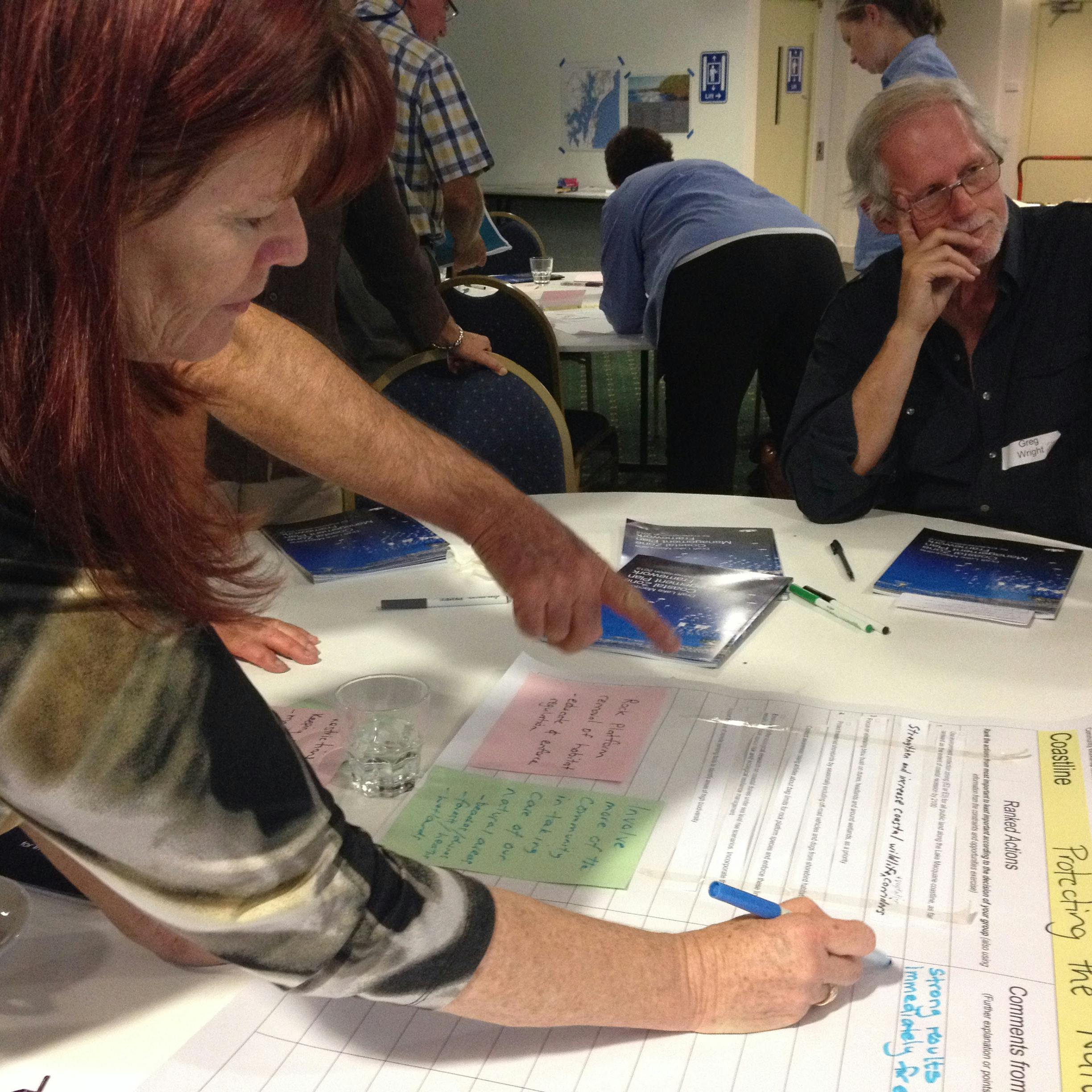 Community Workshop at Blacksmiths Surf Club - 19 November

Project status
-
2011
Coastal Zone Management Plan has finished this stageUpdate the Lake Macquarie Coastal Zone Management Plan
-
2012
Coastal Zone Management Plan has finished this stageUndertake Part A of the Coastal Zone Management Plan
- Draft Coastline Hazard and Risk Assessment
- Draft Coastline Management Options Study
- Draft Lake Macquarie Coastal Zone Management Plan: Part A for Coastline -
2013
Coastal Zone Management Plan has finished this stageUndertake Part B of the Coastal Zone Management Plan
- Draft Lake Macquarie Coastal Zone Management Plan: Part B for the Estuary
Undertake Part C of the Coastal Zone Management Plan
- Draft Lake Macquarie Coastal Zone Management Plan: Part C - Swansea Channel Risk Management Plan -
2014
Coastal Zone Management Plan has finished this stageDraft Lake Macquarie Coastal Zone Management Plan: Part C – Swansea Channel Risk
Management Plan -
October 2014 - January 2015
Coastal Zone Management Plan has finished this stageSeeking feedback on Draft Coastal Zone Management Plan
-
End January 2015
Coastal Zone Management Plan has finished this stagePublic exhibition period closes
-
April 2015
Coastal Zone Management Plan is currently at this stageFinal draft incorporating feedback to Council for approval to submit to Minister for Environment.