
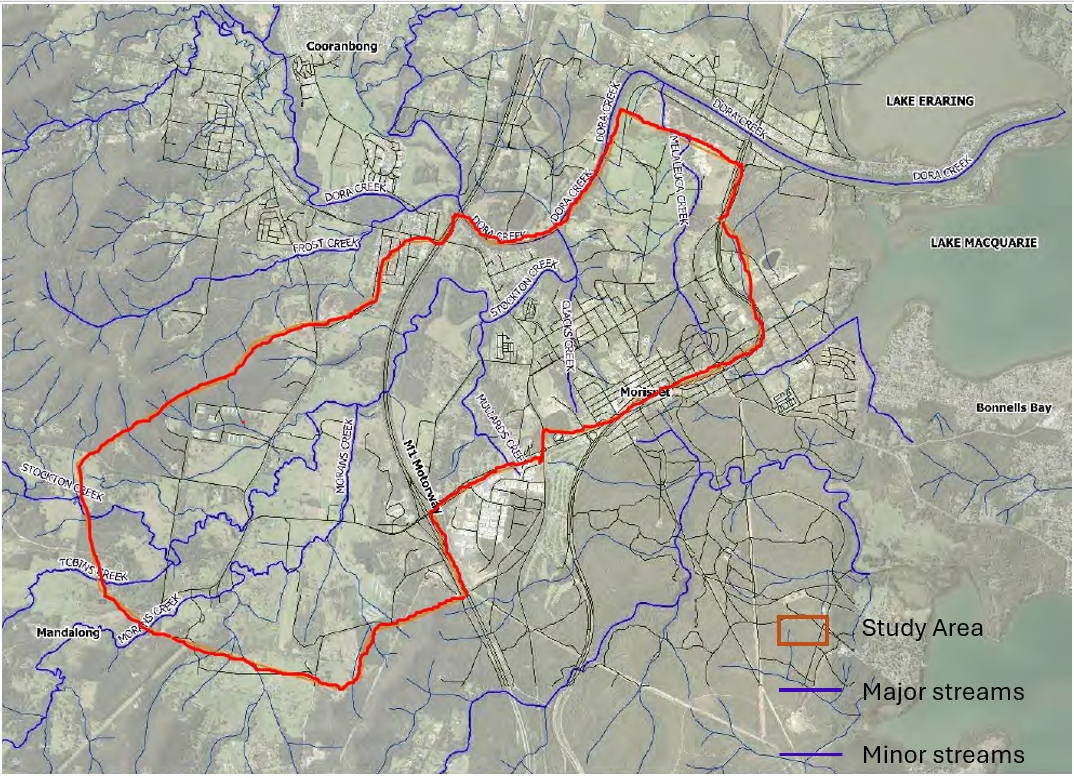
Morisset flood study investigation areas
The flood study includes Morans Creek, Stockton Creek, Upper Dora Creek, Mulards Creek, Clacks Creek and Melaleuca Creek, as shown in the image below.

The Morans Creek , Stockton Creek, Upper Dora Creek, Mulards Creek, Claks Creek and Melaleuca Creek Flood Study ("Stockton and Neighbouring Creeks Flood Study") was adopted by Council on 8 December 2025. Thank you for your participation in this project.
In 2023, Council successfully secured state government funding from the NSW Department of Primary Industries and Regional Development to undertake a flood study for the broader Morisset area. The study identifies areas at risk of flooding and will help inform development controls and planning for the area to ensure that it remains resilient to flooding events.
Environmental and engineering consultants, Engeny, have been engaged to develop a flood study for various creeks in the Morisset area, providing crucial data on flood risks to guide future development and enhance community safety. This comprehensive study complements the Dora Creek study from 2015 and includes advanced modelling and community input to assess flood scenarios and potential impacts.
The flood study was undertaken in accordance with the Flood Risk Management Manual and includes hydraulic and hydrological modelling, model calibration, as well as analysis of different climate change scenarios and a damage assessment. The study also identified various flood depths, velocities, as well as flood extents and flood hazard categories.
Community consultation was an important part of the study, with letters sent to the landowners in the study area and to the Mandalong Community Association in August 2023 to invite them to complete a questionnaire about their flood experiences.
Once adopted, the flood study will be used to inform the Morisset Place Strategy, as well planning certificates and minimum floor levels for new development. Once finalised, the study will be accessible on the Council's website and the NSW SES Flood Data Portal.
The flood study includes Morans Creek, Stockton Creek, Upper Dora Creek, Mulards Creek, Clacks Creek and Melaleuca Creek, as shown in the image below.
This Flood Study was adopted by Council on 8 December 2025.
Under NSW planning laws, councils are responsible for managing local flood planning. This study will enable Council to enact future measures to improve safety and resilience for residents in the broader Morisset area.
Council has engaged a consultant, Engeny Water Management, to complete the flood study. The outcomes and recommendations from the study will improve protection for properties, assist planning for residential growth and development and improve management of our waterways. The flood study will help to inform future planning in and around Morisset, which has been identified as a key growth area under the Hunter Regional Plan 2041.
The final flood study will act as a supporting document to the Morisset Place Strategy.
The Place Strategy will consider biodiversity, flooding, transport and other relevant planning matters usually considered through individual land rezoning proposals.
A flood study is required to be undertaken for Morans Creek, Stockton Creek, Upper Dora Creek, Mulards Creek, Clacks Creek and Melaleuca Creek and adjoining land that is impacted by flooding from these creeks.
The NSW Flood Prone Land Policy aims to reduce the impacts of flooding and flood liability on communities, reduce the private and public losses resulting from floods and increase community resilience to floods. The management of flood-liable land is primarily the responsibility of local government. The NSW Government provides guidance to councils on how to achieve this through the Flood Risk Management Manual 2023 (the Manual). The Manual outlines the flood risk management process as follows:
The Draft Stockton Creek and Neighbouring Creeks Flood Study constitute the first and second stages of the flood risk management process, being data collection and a flood study.
In Lake Macquarie City, there are 10 major catchments feeding into the lake and Council has adopted flood studies and flood risk management plans for all of the major catchments and most of the minor catchments.
The results of the study should assist Council by providing a better understanding of flood behaviour, flood hazard and flood risk in the study area to both allow Council and other agencies to plan and manage these risks based on the best possible information.
In accordance with the NSW Flood Risk Management Manual, the properties that are identified in the flood study as being impacted by the one per cent annual exceedance probability flood event are designated and conditioned as Flood Control Lot - High Hazard. These properties will be subject to flood planning controls, allowing for an appropriate freeboard if required.
Flood information will also be made available on Section 10.7 planning certificates to let existing and future owners know that a property may be potentially flood prone, up to and including the Probable Maximum Flood (PMF) event.
The annual exceedance probability (AEP) is the chance of a specific size flood occurring in any one year, expressed as a percentage. A one per cent AEP flood has a one per cent or 1 in 100 chance of being reached or exceeded in any given year.
Insurers use data from a variety of sources including historical flood measurements, Federal, State and Local government studies, the Insurance Council of Australia’s National Flood Information Database and their own research (i.e. own assessment of risk). In essence, different companies will assess the risk in different ways and Council does not control what flood data insurers choose to use or how they use it. Over the past few years, a number of factors have combined to raise the price of flood cover and insurance more generally. These include:
• the cost of claims generated by the series of major disasters (including storms, flooding and bush fire) since 2010
• Australian insurers paying more for reinsurance (insurance that insurers take out to cover major events) because of these disasters
• changes in understanding where and when floods will occur and how much it costs to fix damage.
The Insurance Council of Australia advised Council that people should shop around if they are dissatisfied with the cost or coverage of their flood insurance. Residents are also advised to look carefully at what they are covered for, rather than just basing their decision on the price. For further information on insurance, residents can visit: About us - Insurance Council of Australia.
At the start of the project, the landowners in the study area received a letter with information about the project and the opportunity to share their observations and experiences of flooding. The wider Lake Macquarie community were also given the opportunity to find out about the project and contribute feedback via Council’s online community engagement platform, Shape Lake Mac. Community consultation ran from 7 to 31 August 2023. A total of 36 responses were received, with 25 of these indicating they had experienced flooding in the past.
Feedback may result in changes being made to the Draft Flood Study prior to a report being prepared for Council.
You will be notified again, prior to Council considering the matter, which will include a link to the Council report containing a summary of submissions and how feedback was considered.
